
Air quality monitoring
The Northern Territory Environment Protection Authority (NT EPA) monitors air quality at stations in Winnellie and Palmerston.
These stations monitor a number of different pollutants and collect meteorological data.
Air quality information from the stations is available in near real time on the Northern Territory Air Quality Network website.
The main pollutant in the Top End region is smoke from distant and local vegetation burning during the Dry Season.
This is represented as particulates of less than 10 microns (PM10) and less than 2.5 microns (PM2.5).
Go to the NT EPA website for more information on air pollutants and air quality data reports.
Environment data
You can find Northern Territory (NT) environment data and information on the following web portals and resources.
The majority of the data listed below is managed by the Department of Lands, Planning and Environment.
For more information call 08 8995 5300 or email landinfo@nt.gov.au.
| NT resources | Data description |
|---|---|
| |
| Fisheries research |
|
| FloraNT |
|
| Geoscience information |
|
| Lands and planning |
|
| Department of Trade, Business and Asian Relations |
|
| NT Aerial Photography Index |
|
| NT Atlas and Spatial Data Directory |
|
| NT Herbarium and native plants |
|
| North Australia and Rangelands Fire Information (NAFI) |
|
| Northern Territory Environment Protection Authority (NTEPA) |
|
| NRM InfoNet |
|
| Parks and reserves |
|
| Other resources | Description |
| Atlas of Living Australia |
|
| data.gov.au |
|
| Geoscience Australia |
|
| The Australasian Virtual Herbarium |
|
Darwin Harbour biodiversity monitoring
The health of marine biodiversity in Darwin Harbour is monitored by mapping and characterising underwater habitats, and monitoring seagrass habitats and dolphins.
Mapping seafloor habitats
Mapping seafloor habitats helps understand the range of estuarine and marine habitats, including coral reefs, seagrass meadows and mudflats.
Bathymetric (depth) mapping uses a multi-beam echo sounder system and has mapped all subtidal areas of the Darwin Harbour area.
Then the seafloor is biologically surveyed using grab samples, trawls and remote video cameras.
This helps describe the type of sediment and the animals and plants living there.
The different layers of information are then combined to identify and map the habitats of the harbour.
Read more on marine habitat mapping.
Dolphin monitoring
Three species of coastal dolphin live in NT waters, these are all of the following:
- Australian snubfin
- Indo-Pacific humpback
- Indo-Pacific bottlenose.
All three dolphins live in Darwin Harbour and have been monitored since 2008 to understand how each uses the harbour. This program has expanded to include Bynoe Harbour and Shoal Bay.
Individual animals can be identified through photographing their dorsal fin, which have unique markings and scars. This helps assess the health of these individuals.
Seagrass monitoring
Seagrass meadows play an important role supporting coastal marine communities and diverse flora and fauna.
Seagrass also maintains coastal water quality and clarity.
Seagrass meadows support coastal fisheries as they are nurseries for many commercially and recreationally important species.
Seagrass is the favourite food for dugongs and an important habitat for many marine species.
Seagrass health is linked with dugong population numbers and health, and often shows the overall ecosystem health.
Important local seagrass meadows in Darwin Harbour are found at Casuarina Coastal Reserve, Mindil Beach, Fannie Bay and West Arm.
A seagrass watch program started in 2011, working with local schools to survey seagrass at Mindil, Vesteys and Casuarina beaches.
Fauna atlas
The Northern Territory (NT) fauna atlas currently includes all known terrestrial vertebrate records for the NT.
It has more than one million records and is the most comprehensive database available of mammals, birds, reptiles and frogs.
It is used to work out where species can be found and make sure these species are protected.
Data is collected by scientists, from museums, environmental consultants, researchers and historical accounts.
View the fauna atlas on NR Maps.
Contribute to the NT fauna atlas
You can submit your fauna records to the fauna atlas on the fauna observations page of NT Wildwatch.
If you have any questions, email biodiversity@nt.gov.au.
Flora atlas
The Northern Territory (NT) flora atlas has over one million plant records.
Data comes from the NT Herbarium specimen database and the vegetation site database of the NT.
The NT Herbarium database has records of plants that have been collected in the field where a sample of that plant has been preserved, identified and kept in the Herbarium.
Data in the vegetation site database includes basic plant observations to detailed flora surveys.
Find out more about the NT Herbarium.
Marine and coastal biodiversity
The Northern Territory (NT) has one of the world's most intact marine environments so it is important to protect its marine and coastal biodiversity.
The Territory is also home to the largest area of mangrove forest in Australia.
The NT marine habitats, such as coral reefs, seagrass meadows, mangroves and sand or mudflats are important hotspots for biodiversity.
They are important breeding, nursery and feeding areas for many species, including marine turtles and colonies of shorebirds, seabirds and waterbirds, as well as dolphins, dugongs, sawfish, sea snakes, seahorses, sharks and rays.
Many of these species are common in NT waters where they have declined in other regions and now are listed as threatened species.
Marine ecosystems are connected. Species regularly move across large areas and into waters outside the NT and Australian borders.
The quality of the NT marine environment depends greatly on how marine resources are used and how nearby terrestrial areas are managed.
They can also be affected by natural disturbances and global factors.
Report a marine wildlife incident
If you come across injured or sick marine wildlife, report it as soon as possible.
Find out how to report a marine wildlife incident or injury.
Natural Resource Maps NT
Natural Resource (NR) Maps is a web mapping tool to discover, research and map natural and cultural research data for the Northern Territory (NT).
Go to the NR Maps website.
You can do all of the following with NR Maps:
- display, select and query data layers sourced from different government agencies
- access NT data including:
- soil
- water and vegetation resource surveys
- flora and fauna species
- weeds
- bores
- water management areas
- download NT data layers and export query results
- access more than 600 NT map PDF documents
- draw redline mark-ups and export to shapefiles
- upload your own data in a range of formats
- create A4 or A3 PDF maps to print and save.
For more information about NR Maps or to get user guides, go to the Department of Lands, Planning and Environment website.
Water data
You can access current and past groundwater, surface water and water quality data on the Water Data Portal or through Natural Resource Maps Northern Territory.
Water testing in the Katherine region
Testing for chemicals linked with firefighting foams in ground and surface water took place near RAAF Base Tindal in November 2016.
The testing was conducted to find out where the chemicals are in the aquifer.
The chemicals, per- and poly-fluoroalkyl substances (PFAS), were previously used in firefighting foams around Australia.
To find out more go to the Fire Fighting Foam (PFAS) Investigation page on the Northern Territory Environmental Protection Authority website.
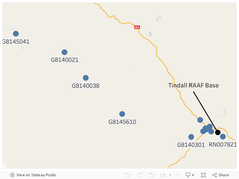
Where samples were taken
Six monitoring bores and three surface water sites on Crown land near RAAF Base Tindal were tested.
What the tests found
The results found PFAS along the flow of the aquifer in a west to north-west direction between RAAF Base Tindal and the Katherine River.
PFAS were not detected upstream from the source or on the northern side of the Katherine River.
The results have been given to the Department of Defence to help with its investigation into PFAS in ground and surface water.
For results from each sampling site see the interactive map below.
Contact
For more information call the NT EPA Pollution Hotline on 1800 064 567.
Detailed site investigation at Alice Springs Fire Station
In 2021 a detailed site investigation (DSI) of the Alice Springs Fire Station commenced after soil sampling showed elevated levels of per- and poly-fluoroalkyl substances (PFAS) at the site.
Learn about PFAS on the Northern Territory Environmental Protection Authority website.
Field investigations
Field investigation were conducted in early 2023.
Follow up investigations are ongoing at the fire station.
There is no immediate public health risk or cause for concern to nearby residents.
Water testing
Alice Springs drinking water show no detectable levels of PFAS and is safe to drink.
Power and Water regularly test the water.
Read more about PFAS testing of drinking water on the Power and Water website.
Results of the investigation
Results will be made available after the completion of the DSI.
For more information
Call the taskforce on 08 8999 4051 or email pfas.taskforce@nt.gov.au.