Cyclone plan for wharves and moorings
A cyclone plan sets out roles and responsibilities for managing harbour infrastructure, vessels in the harbour and staff during a cyclone event.
All users of port areas must follow a cyclone plan to:
- minimise risk to life and property
- minimise risk and damage to infrastructures
- make an effective contribution to a cyclone emergency response.
Darwin Port areas
The cyclone plan you must follow during a cyclone event depends on where your vessel is located.
Frances Bay Mooring Basin (Duck Pond)
For vessels in the Duck Pond, vessel owners must follow the Frances Bay facilities’ cyclone procedure plan 2021-2022 PDF (557.9 KB).
This includes all vessels in the following facilities:
- Frances Bay Mooring Basin
- Fisherman's and Raptis wharves
- Hornibrooks Wharf - including pontoon and careening poles
- Sadgroves Creek Moorings.
The plan will be activated by the general manager operations of Darwin Port and the harbour control officer.
Their directions to vessel masters, crew and port operators will take priority over other cyclone plans.
Other areas
For the rest of the Darwin Port areas outside the Frances Bay area, read the cyclone plan from the Darwin Port website.
Areas outside Darwin Port
If you’re outside the Darwin Port, you must have your own cyclone plan.
You should also refer to the Darwin Port cyclone plan on the Darwin Port website.
The directions and emergency contacts in the plan apply to you whether you’re in the Darwin Port boundary or not.
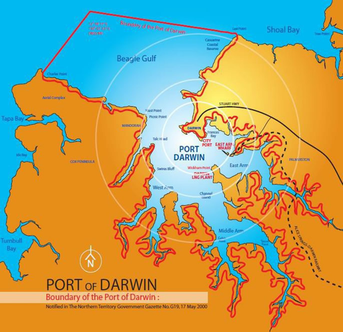
Darwin Port limits
The red lines on the map below outline the Darwin Port boundary.
Everything in the boundary is under the Darwin Port jurisdiction and is their responsibility.

Contact
For more information, read contacts for mariners.
Give feedback about this page.
Share this page:
URL copied!