Water allocation framework
The Northern Territory (NT) water allocation planning (WAP) framework guides how water resources are shared and used within and outside water allocation plan areas.
The framework is based on the principle that water resources are a shared public resource that need to be managed sustainably and fairly.
This means that all water users have a right to access water resources in a manner that balances their needs with the needs of the environment and the broader community.
The framework sets out how water is to be shared between:
- consumptive uses, like agriculture
- non-consumptive uses, like environmental or cultural uses.
Priority
The framework prioritises water allocation to non-consumptive beneficial uses.
Once this allocation is set, remaining water can be allocated to consumptive beneficial uses.
Allocations
The framework has a flexible approach to sharing water resources, especially where scientific research on environmental or cultural water needs is not available.
These contingent allocations are designed to be adaptable, so they can be adjusted as new information becomes available.
The framework is sometimes referred to as the '80:20' rule, which means that 80% of available water is assigned to non-consumptive uses, while 20% is assigned to consumptive uses.
For more information, read the NT WAP framework PDF (430.1 KB).
Zones
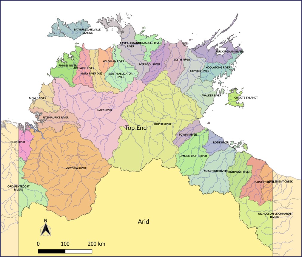
The NT has 2 main climatic zones that affect how water is allocated based on the framework.
These zones are the:
- Top End - it covers the northern one third of the NT. It has a noticeable wet and dry season.
- Arid zone - it covers the southern two thirds of the NT. It has no clear wet season.
The following helps to decide which zone a resource belongs to.
Top End
- Distinct wet and dry season, with over 95% of rainfall happens between October to April
- Rainfall greater than 600mm in most years
- Seasonal runoff of greater than 0.5ML per hectare in most years
- Streamflow with daily peak flows more than 10 times average wet season flows
- Seasonal (wet season) groundwater recharge in most years
Arid zone
- No distinct wet season, less than 95% of rainfall happens between October to April
- Variable and episodic rainfall, with less than 600mm occurring in most years
- Runoff of less than 0.5ML per hectare per year, commonly with consecutive years of no streamflow
- Groundwater recharge occurs rarely or not at all
Read more about the classification of Top End and Arid zone water resources.
Map of zones
The map below shows which geographical locations belong to which zone.
Taking surface water
There are rules and conditions for taking surface water in the Top End during the wet season.
The surface water take - wet season flows policy sets out:
- how an application is assessed to take surface water from river basins in the Top End during the wet season
- any management actions that apply.
Read the policy PDF (579.3 KB).

